-
Invited speaker at UBISOFT Procedural Days
December 19, 2019
 I will make a presentation on procedural
modeling at UBISOFT Paris: Orometry-based terrains.
I will make a presentation on procedural
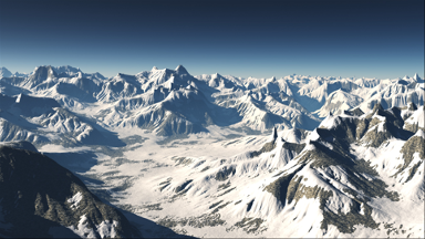
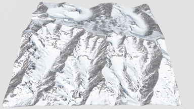
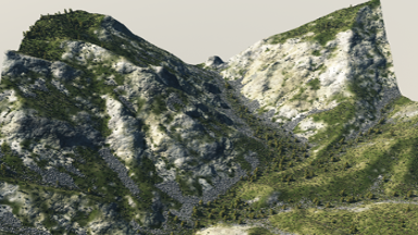
modeling at UBISOFT Paris: Orometry-based terrains.In this presentation, we present orometry-based terrain analysis, classification and synthesis. More precisely, we show how to analyze terrains, construct a sparse metric computed on the peaks and saddles, classify terrains and learn from the relief features to synthesize realistic terrains with distinctive landforms.
We construct a sparse metric computed on the peaks and saddles of a mountain range and show that, when used for classification, this is capable of robustly distinguishing between different mountain ranges. We then present a synthesis method that takes a coarse elevation map as input and builds a graph of peaks and saddles respecting a given orometric distribution.
-
Orometry-based terrains
August 29, 2019
 Our paper Orometry paper has been accepted at SIGGRAPH ASIA 2019.
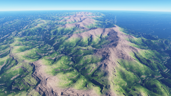
Mountainous digital terrains are an important element of many virtual environments and find application in games, film, simulation and training. Unfortunately, while existing synthesis methods produce locally plausible results they often fail to respect global structure. This is exacerbated by a dearth of automated metrics for assessing terrain properties at a macro level. We address these issues by building on techniques from orometry, a field that involves the measurement of mountains and other relief features. First, we construct a sparse metric computed on the peaks and saddles of a mountain range and show that, when used for classification, this is capable of robustly distinguishing between different mountain ranges. Second, we present a synthesis method that takes a coarse elevation map as input and builds a graph of peaks and saddles respecting a given orometric distribution. This is then expanded into a fully continuous elevation function by deriving a consistent river network and shaping the valley slopes. In terms of authoring, users provide various control maps and are also able to edit, reposition, insert and remove terrain features all while retaining the characteristics of a selected mountain range.
-
Riverscapes
August 29, 2019
 Our paper on Procedural Riverscapes has been accepted at Pacific Graphics 2019.
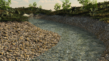
This paper addresses the problem of creating animated riverscapes through a novel procedural framework that generates the inscribing geometry of a river network and then synthesizes matching real-time water movement animation. Our approach takes bare-earth heightfields as input, derives hydrologically-inspired river network trajectories, carves riverbeds into the terrain, and then automatically generates a corresponding blend-flow tree for the water surface. The water surface is defined as a time-varying continuous function encoded as a blend-flow tree with leaves that are parameterized procedural flow primitives and internal nodes that are blend operators. The resulting framework enables the generation of a wide range of river forms, ranging from slow meandering rivers to rapids with churning water, including surface effects, such as foam and leaves carried downstream.
-
Desertscapes
August 29, 2019
 Our paper Desertscape Simulation has been accepted at Pacific Graphics 2019.
We present an interactive aeolian simulation to author hot desert scenery. Wind is an important erosion agent in deserts which, despite its importance, has been neglected in computer graphics. Our framework overcomes this and allows generating a variety of sand dunes, including barchans, longitudinal and anchored dunes, and simulates abrasion which erodes bedrock and sculpts complex landforms. Given an input user-defined time varying high altitude wind field, we compute the wind field at the surface of the terrain according to the relief, and simulate the transport of sand blown by the wind. The user can interactively model complex desert landscapes, and control their evolution throughout time either by using a variety of interactive brushes or by prescribing events along a user-defined time-line.
-
Implicit Surfaces for Modeling 3D Terrains
June 19, 2019
 Our paper Terrain Amplification with Implicit 3D Features has been accepted at ACM
Transactions on Graphics and will be presented at SIGGRAPH ASIA 2019.
Our paper Terrain Amplification with Implicit 3D Features has been accepted at ACM
Transactions on Graphics and will be presented at SIGGRAPH ASIA 2019.
We present a novel memory-optimized paradigm for representing and generating volumetric terrain based on implicit surfaces. We encode feature shapes and terrain geology using construction trees that arrange and combine implicit primitives. The landform primitives themselves are positioned using Poisson sampling, built using open shape grammars guided by stratified erosion and invasion percolation processes, and, finally, queried during polygonization. Users can also interactively author landforms using high-level modeling tools to create or edit the underlying construction trees, with support for iterative cycles of editing and simulation.
-
Houdini licences
March 13, 2019
We thank Side Effects Software for providing Houdini licences to our team.
Our team will use the Houdini environment for testing and developping natural phenomena algorithms.
-
Terrain Generation at Eurographics 2019
March 12, 2019
 Our State of the Art review of terrain generation has been accepted at
Eurographics.
Our State of the Art review of terrain generation has been accepted at
Eurographics.Terrain modeling methods focus on capturing landforms in all their intricate detail, including eroded valleys arising from the interplay of varied phenomena, dendritic mountain ranges, and complex river networks. Set against this visual complexity is the need for user control over terrain features, without which designers are unable to adequately express their artistic intent. This article provides an overview of current terrain modeling and authoring techniques, organized according to three categories: procedural modeling, physically-based simulation of erosion and land formation processes, and example-based methods driven by scanned terrain data. We compare and contrast these techniques according to several criteria, specifically: the variety of achievable landforms; realism from both a perceptual and geomorphological perspective; issues of scale in terms of terrain extent and sampling precision; the different interaction metaphors and attendant forms of user-control, and computation and memory performance.
-
Branching basis functions for noise at I3D 2019
February 15, 2019
A procedural Model for Dendritic Patterns has been accepted at ACM SIGGRAPH Symposium on Interactive 3D Graphics and Games.
We introduce a procedural function that generates dendritic patterns and is locally computable. The function is controlled by parameters such as the level of branching, the degree of local smoothing, random seeding and local disturbance parameters, andthe range of the branching angles. It is also controlled by a global control function that defines the overall shape and can be used,for example, to initialize local minima. The algorithm returns the distance to a tree structure which is implicitly constructed on the fly, while requiring a small memory footprint. The evaluation canbe performed in parallel for multiple points and scales linearly with the number of cores. We demonstrate an application of our model to the generation of terrain heighfields with consistent river networks.
-
Procedural Tectonic Planets at Eurographics 2019
February 15, 2019
 Our paper has been accepted at Eurographics.
We present a procedural method for authoring synthetic tectonic planets. Instead of relying on computationally demanding physically-based simulations, we capture the fundamental phenomena into a procedural method that faithfully reproduces largescale planetary features generated by the movement and collision of the tectonic plates. We approximate complex phenomena such as plate subduction or collisions to deform the lithosphere, including the continental and oceanic crusts. The user can control the movement of the plates, which dynamically evolve and generate a variety of landforms such as continents, oceanic ridges, large scale mountain ranges or island arcs. Finally, we amplify the large-scale planet model with either procedurallydefined or real-world elevation data to synthesize coherent detailed reliefs. Our method allows the user to control the evolution of an entire planet interactively, and to trigger specific events such as catastrophic plate rifting.
-
Procedural Cloudscapes at Eurographics 2018
January 18, 2018
 Procedural Cloudscapes has been accepted at Eurographics.
We present a phenomenological approach for modeling and animating cloudscapes. We propose a compact procedural model for representing the different types of cloud over a range of altitudes. We define primitive-based field functions that allows the user to control and author the cloud cover over large distances easily. Our approach allows us to animate cloudscapes by morphing: instead of simulating the evolution of clouds using a physically-based simulation, we compute the movement of clouds using key-frame interpolation and tackle the morphing problem as an Optimal Transport problem. The trajectories of the cloud cover primitives are generated by solving an Anisotropic Shortest Path problem with a cost function that takes into account the elevation of the terrain and the characteristics of the wind field.
-
Snow-Covered Landscapes at Eurographics 2018
January 18, 2018
 Interactive Generation of Time-evolving, Snow-Covered Landscapes with Avalanches has
been accepted at Eurographics.
Interactive Generation of Time-evolving, Snow-Covered Landscapes with Avalanches has
been accepted at Eurographics.We introduce a novel method for interactive generation of visually consistent, snow-covered landscapes and provide control of their dynamic evolution over time. Our main contribution is the real-time phenomenological simulation of avalanches and other user-guided events, such as tracks left by Nordic skiing, which can be applied to interactively sculpt the landscape. The terrain is modeled as a height field with additional layers for stable, compacted, unstable, and powdery snow, which behave in combination as a semi-viscous fluid. We incorporate the impact of several phenomena, including sunlight, temperature, prevailing wind direction, and skiing activities. The snow evolution includes snow-melt and snow-drift, which affect stability of the snow mass and the probability of avalanches. A user can shape landscapes and their evolution either with a variety of interactive brushes, or by prescribing events along a winter season time-line. Our optimized GPU-implementation allows interactive updates of snow type and depth across a large terrain, including real-time avalanches, making this suitable for visual assets in computer games.
-
Invited speaker at UBISOFT Procedural Days
December 14, 2017
I will make a presentation on procedural modeling at UBISOFT Paris: Authoring Landscapes by Combining Ecosystem and Terrain Erosion Simulation.
In this presentation, I will introduce a novel framework for interactive landscape authoring that supports bi-directional feedback between erosion and vegetation simulation. Vegetation and terrain erosion have strong mutual impact and their interplay influences the overall realism of virtual scenes. I will show how to simulate the effect of a variety of geomorphological agents and the mutual interaction between different material and vegetation layers, including rock, sand, humus, grass, shrubs, and trees.
-
Deep Terrains at SIGGRAPH ASIA
September 4, 2017
 Interactive Example-Based
Terrain Authoring with Conditional Generative Adversarial Networks has been accepted
at SIGGRAPH ASIA.
Interactive Example-Based
Terrain Authoring with Conditional Generative Adversarial Networks has been accepted
at SIGGRAPH ASIA.
Watch Terrain Generation With Deep Learning | Two Minute Papers #208
Authoring virtual terrains presents a challenge and there is a strong need for authoring tools able to create realistic terrains with simple user-inputs and with high user control. We propose an example-based authoring pipeline that uses a set of terrain synthesizers dedicated to specific tasks. Each terrain synthesizer is a Conditional Generative Adversarial Network trained by using real-world terrains and their sketched counterparts. The training sets are built automatically with a view that the terrain synthesizers learn the generation from features that are easy to sketch. During the authoring process, the artist first creates a rough sketch of the main terrain features, such as rivers, valleys and ridges, and the algorithm automatically synthesizes a terrain corresponding to the sketch using the learned features of the training samples. Our framework allows for an easy terrain authoring and provides a high level of realism for a minimum sketch cost. We show various examples of terrain synthesis created by experienced as well as inexperienced users who are able to design complex and diverse terrains in a very short time.
-
Full Professor Position at Université Lyon 1
September 1, 2017
I moved to Université Lyon 1 where I hold a full professor position in the computer science department.
I am teaching Master classes in computer graphics, and undergraduate courses in object oriented programming and algorithmics.
-
GEOMOD at SIGGRAPH
May 15, 2017
 Our paper Authoring
Landscapes by Combining Ecosystem and Terrain Erosion Simulation has been accepted
at SIGGRAPH.
Our paper Authoring
Landscapes by Combining Ecosystem and Terrain Erosion Simulation has been accepted
at SIGGRAPH.We introduce a novel framework for interactive landscape authoring that supports bi-directional feedback between erosion and vegetation simulation. Vegetation and terrain erosion have strong mutual impact and their interplay influences the overall realism of virtual scenes. Despite their importance, these complex interactions have been neglected in computer graphics. Our framework overcomes this by simulating the effect of a variety of geomorphological agents and the mutual interaction between different material and vegetation layers, including rock, sand, humus, grass, shrubs, and trees. Users are able to exploit these interactions with an authoring interface that consistently shapes the terrain and populates it with details.
-
Eurographics 2017 in Lyon
April 24-28, 2017
 The GeoMod team had the
pleasure to organize and welcome the prestigious conference Eurographics 2017 April
24th-28th in Lyon's Convention
Center. This event was a clear success as we received more than 400 researchers and
industrials for 79 hours of scientific presentations around
various computer graphics topics: geometry and modeling, image and video processing,
rendering, simulation, 3D printing. The symbiosis
between academic and industrial research culminated during four plenary sessions, making us
discover computational photography (Frédo Durand,
MIT), the joy of computer graphics programming (Bruno Lévy, INRIA), the secrets of Hollywood
movies (Parolo Emilio Selva, Weta Digital) and the
mysteries of time (Jos Stam, Autodesk). LIRIS thanks the local organizing team led by Eric
Galin and applauds the success of Eurographics 2017!
The GeoMod team had the
pleasure to organize and welcome the prestigious conference Eurographics 2017 April
24th-28th in Lyon's Convention
Center. This event was a clear success as we received more than 400 researchers and
industrials for 79 hours of scientific presentations around
various computer graphics topics: geometry and modeling, image and video processing,
rendering, simulation, 3D printing. The symbiosis
between academic and industrial research culminated during four plenary sessions, making us
discover computational photography (Frédo Durand,
MIT), the joy of computer graphics programming (Bruno Lévy, INRIA), the secrets of Hollywood
movies (Parolo Emilio Selva, Weta Digital) and the
mysteries of time (Jos Stam, Autodesk). LIRIS thanks the local organizing team led by Eric
Galin and applauds the success of Eurographics 2017! -
CGI Paper: Landscapes
April 14, 2017
Our paper Coherent Multi-Layer Landscape Synthesis has been accepted at CGI.
 We present an effcient method for generating coherent multi-layer landscapes. We use a
dictionary built from exemplars to synthesize high-resolution
fully-featured terrains from input low-resolution elevation data. Our example-based method
consists in analyzing real world terrain examples and learning the
procedural rules directly from these inputs. We take into account not only the elevation of
the terrain, but also additional layers such as the slope, orientation,
drainage area, the density and distribution of vegetation, and the soil type. By increasing
the variety of terrain exemplars, our method allows the user to synthesize and control
different types of landscapes and biomes, such as temperate or rain forests, arid deserts
and mountains.
We present an effcient method for generating coherent multi-layer landscapes. We use a
dictionary built from exemplars to synthesize high-resolution
fully-featured terrains from input low-resolution elevation data. Our example-based method
consists in analyzing real world terrain examples and learning the
procedural rules directly from these inputs. We take into account not only the elevation of
the terrain, but also additional layers such as the slope, orientation,
drainage area, the density and distribution of vegetation, and the soil type. By increasing
the variety of terrain exemplars, our method allows the user to synthesize and control
different types of landscapes and biomes, such as temperate or rain forests, arid deserts
and mountains. -
IEEE Transactions on Visualization and Computer Graphics
March 27, 2017
Our paper Sculpting Mountains: Interactive Terrain Modeling Based on Subsurface Geology has been accepted at IEEE TVCG.
 Most mountain ranges are formed by the compression and folding of colliding tectonic plates.
Subduction of one plate
causes large-scale asymmetry while their layered composition (or stratigraphy) explains the
multi-scale folded strata observed on real
terrains. We introduce a novel interactive modeling technique to generate visually
plausible, large scale terrains that capture these
phenomena. Our method draws on both geological knowledge for consistency and on sculpting
systems for user interaction. The user
is provided hands-on control on the shape and motion of tectonic plates, represented using a
new geologically-inspired model for the
Earth crust. The model captures their volume preserving and complex folding behaviors under
collision, causing mountains to grow. It
generates a volumetric uplift map representing the growth rate of subsurface layers. Erosion
and uplift movement are jointly simulated
to generate the terrain. The stratigraphy allows us to render folded strata on eroded
cliffs. We validated the usability of our sculpting
interface through a user study, and compare the visual consistency of the earth crust model
with geological simulation results and real
terrains.
Most mountain ranges are formed by the compression and folding of colliding tectonic plates.
Subduction of one plate
causes large-scale asymmetry while their layered composition (or stratigraphy) explains the
multi-scale folded strata observed on real
terrains. We introduce a novel interactive modeling technique to generate visually
plausible, large scale terrains that capture these
phenomena. Our method draws on both geological knowledge for consistency and on sculpting
systems for user interaction. The user
is provided hands-on control on the shape and motion of tectonic plates, represented using a
new geologically-inspired model for the
Earth crust. The model captures their volume preserving and complex folding behaviors under
collision, causing mountains to grow. It
generates a volumetric uplift map representing the growth rate of subsurface layers. Erosion
and uplift movement are jointly simulated
to generate the terrain. The stratigraphy allows us to render folded strata on eroded
cliffs. We validated the usability of our sculpting
interface through a user study, and compare the visual consistency of the earth crust model
with geological simulation results and real
terrains. -
Ghost Recon Wildlands Released
March 17, 2017
Ghost Recon Wildlands road networks were generated using an implementation based on the algorithms of our 2011 and 2012 papers published in Computer Graphics Forum.
Tom Clancy's Ghost Recon Wildlands is a tactical shooter video game developed by Ubisoft Paris and published by Ubisoft. During the production of the game, we helped the team at Ubisoft Paris to setup the road network generation system based on our 2011 and 2012 papers.
-
Third rank at the Computer Graphics Forum cover competition
February 6, 2017
A picture generated with the method described in the paper Efficient modeling of entangled details for natural scenes and presented at Pacific Graphics 2016, won the third place in the Computer Graphics Forum cover competition.
-
Vue X-Stream licences
January 19, 2017
We thank e-on Software for providing Vue X-Stream licences to our team.
Our code now directly streams output to Vue X-Stream to render landscapes and terrains.
-
Noise
September 15, 2016
The paper Volumetric Spot Noise for procedural 3D Shell Texture Synthesis has been accepted at Computer CGVC16.
we present an extension of the Locally Controlled Spot Noise and a visualization pipeline for volumetric fuzzy details synthesis. We extend the noise model to author volumetric fuzzy details using filtered 3D quadratic kernel functions convolved with a projective non-uniform 2D distribution of impulses. We propose a new method based on order independent splatting to compute a fast view dependent approximation of shell noise at interactive rates. Our method outperforms ray marching techniques and avoids aliasing artifacts, thus improving interactive content authoring feedback. Generated surface details share the same properties as procedural noise: they extend on potentially infinite surfaces, are defined in an extremely compact way, are non-repetitive, continuous and independent of the definition of the underlying surface.
-
ANR Huge Digital Worlds
September 2016 - September 2020
The ANR project Huge Digital Worlds has been accepted and funded by the Agence Nationale pour la Recherche.
In this project, we address the generation, processing and rendering of huge realistic landscapes using an original approach: program-based generative content production, also called procedural modeling. Instead relying on explicit representations, procedural and implicit models generate geometry and/or texture on the fly by using functions and procedures controled by a reduced set of parameters.
-
Modeling entangled details
August 26, 2016
 Our paper Efficient
modeling of entangled details for natural scenes has been accepted at Computer
Graphics Forum.
Our paper Efficient
modeling of entangled details for natural scenes has been accepted at Computer
Graphics Forum.Digital landscape realism often comes from the multitude of details that are hard to model such as fallen leaves, rock piles or entangled fallen branches. In this article, we present a method for augmenting natural scenes with a huge amount of details such as grass tufts, stones, leaves or twigs. Our approach takes advantage of the observation that those details can be approximated by replications of a few similar objects and therefore relies on mass-instancing. We propose an original structure, the Ghost Tile, that stores a huge number of overlapping candidate objects in a tile, along with a pre-computed collision graph. Details are created by traversing the scene with the Ghost Tile and generating instances according to user-defined density fields that allow to sculpt layers and piles of entangled objects while providing control over their density and distribution.
-
Sparse representation of terrains accepted at Eurographics 2016
January 15, 2016
 Our paper Sparse
representation of terrains for procedural modeling has been accepted at
Eurographics.
Our paper Sparse
representation of terrains for procedural modeling has been accepted at
Eurographics.In the sparse modeling paper, we present a simple and efficient method to represent terrains as elevation functions built from linear combinationsof landform features (atoms). These features can be extracted either from real world data-sets or procedural primitives, orfrom any combination of multiple terrain models. Our approach consists in representing the elevation function as a sparsecombination of primitives, a concept which we call Sparse Construction Tree, which blends the different landform featuresstored in a dictionary. The sparse representation allows us to represent complex terrains using combinations of atoms from asmall dictionary, yielding a powerful and compact terrain representation and synthesis tool. Moreover, we present a methodfor automatically learning the dictionary and generating the Sparse Construction Tree model. We demonstrate the efficiency ofour method in several applications: inverse procedural modeling of terrains, terrain amplification and synthesis from a coarsesketch.
-
Tectonic uplift and fluvial erosion
January 15, 2016
Our paper Large Scale Terrain Generation from Tectonic Uplift and Fluvial Erosion has been accepted at Eurographics.
At large scale, landscapes result from the combination of two major processes: tectonics which generate the main relief through crust uplift, and weather which accounts for erosion. This paper presents the first method in computer graphics that combines uplift and hydraulic erosion to generate visually plausible terrains. Given a user-painted uplift map, we generate a stream graph over the entire domain embedding elevation information and stream flow. Our approach relies on the stream power equation introduced in geology for hydraulic erosion. By combining crust uplift and stream power erosion we generate large realistic terrains at a low computational cost. Finally, we convert this graph into a digital elevation model by blending landform feature kernels whose parameters are derived from the information in the graph. Our method gives high-level control over the large scale dendritic structures of the resulting river networks, watersheds, and mountains ridges.
-
Environment Sensitive Objects
January 4, 2016
 Our paper
Environmental
Objects for Authoring Procedural Scene has been accepted at Computer Graphics Forum.
Our paper
Environmental
Objects for Authoring Procedural Scene has been accepted at Computer Graphics Forum.
We propose a novel approach for authoring large scenes with automatic enhancement of objects to create geometric decoration details such as snow cover, icicles, fallen leaves, grass tufts, or even trash. We introduce environmental objects that extend an input object geometry with a set of procedural effects that defines how the object reacts to the environment, and by a set of scalar fields that defines the influence of the object over of the environment. The user controls the scene by modifying environmental variables, such as temperature or humidity fields. The scene definition is hierarchical: objects can be grouped and their behaviors can be set at each level of the hierarchy. Our per object definition allows us to optimize and accelerate the effects computation, which also enables us to generate large scenes with many geometric details at a very high level of detail. In our implementation, a complex urban scene of ten-thousand square meters, represented with details of less than one centimeter, can be locally modified and entirely re-generated in a few seconds.
-
Invited speaker at UBISOFT Procedural Days
November 13, 2015
 I made a presentation on
procedural
generation at UBISOFT Paris: Modeling and generating scenic landscapes.
I made a presentation on
procedural
generation at UBISOFT Paris: Modeling and generating scenic landscapes.In this talk, I will present our latest research on procedural generation of terrains, roads and rivers. I will show that some phenomenological approaches lend themselves for interactive and intuitive control and can be used to generate complex models.
-
PAPAYA
September 2015 - September 2018, Investissements d'Avenir Développement de l'Economie Numérique
The project PAPAYA has been accepted.
-
Terrain Modeling from Feature Primitives
June 15, 2015
 Our paper has been
accepted at Computer Graphics Forum.
Our paper has been
accepted at Computer Graphics Forum.We introduce a compact hierarchical procedural model that combines feature-based primitives to describe complex terrains with varying level of detail. Our model is inspired by skeletal implicit surfaces and defines the terrain elevation function by using a construction tree. Leaves represent terrain features and they are generic parameterized skeletal primitives such as mountains, ridges, valleys, rivers, lakes, or roads. Inner nodes combine the leaves and sub-trees by carving, blending, or warping operators. The elevation of the terrain at a given point is evaluated by traversing the tree and by combining the contributions of the primitives. The definition of the tree leaves and operators guarantees that the resulting elevation function follows the Lipschitz property which speeds up sphere tracing and adaptive tessellation algorithms used to render the terrain. Our model is compact and allows for the creation of large terrains with a high level of detail using a reduced set of primitives. We show the creation of different kinds of landscapes and demonstrate that our model allows to efficiently control the shape and distribution of landform features.
-
Invited speaker at the Collège de France
March 27, 2015
 I will give a talk at the
prestigious Collège de France on procedural generation of virtual worlds.
I will give a talk at the
prestigious Collège de France on procedural generation of virtual worlds.Watch the video of the presentation.
Marie Paule Cani invited me to give a presentation at the Collège de France. In this presentation, I present an overview of challenges in the generation of virtual world and show how procedural modeling can provide some efficient solutions to various complex problems. The slides and vidéo of the presentation and details can be found here.